Script error: No such module "Infobox".
The Berlin S-Bahn is a rapid transit system in and around Berlin, the capital city of Germany. It consists of 15 lines and is integrated with the mostly underground U-Bahn to form the backbone of Berlin's rapid transport system. Unlike the U-Bahn, the S-Bahn crosses the Berlin city and state border into the surrounding state of Brandenburg, mostly from the former East Berlin but today also from West Berlin to Potsdam.
Although the S- and U-Bahn are part of a unified fare system, they have different operators. The S-Bahn is operated by S-Bahn Berlin GmbH, a subsidiary of the Deutsche Bahn, whilst the U-Bahn is run by BVG, the main public transit company for the city of Berlin.
Operation[]
Routes[]
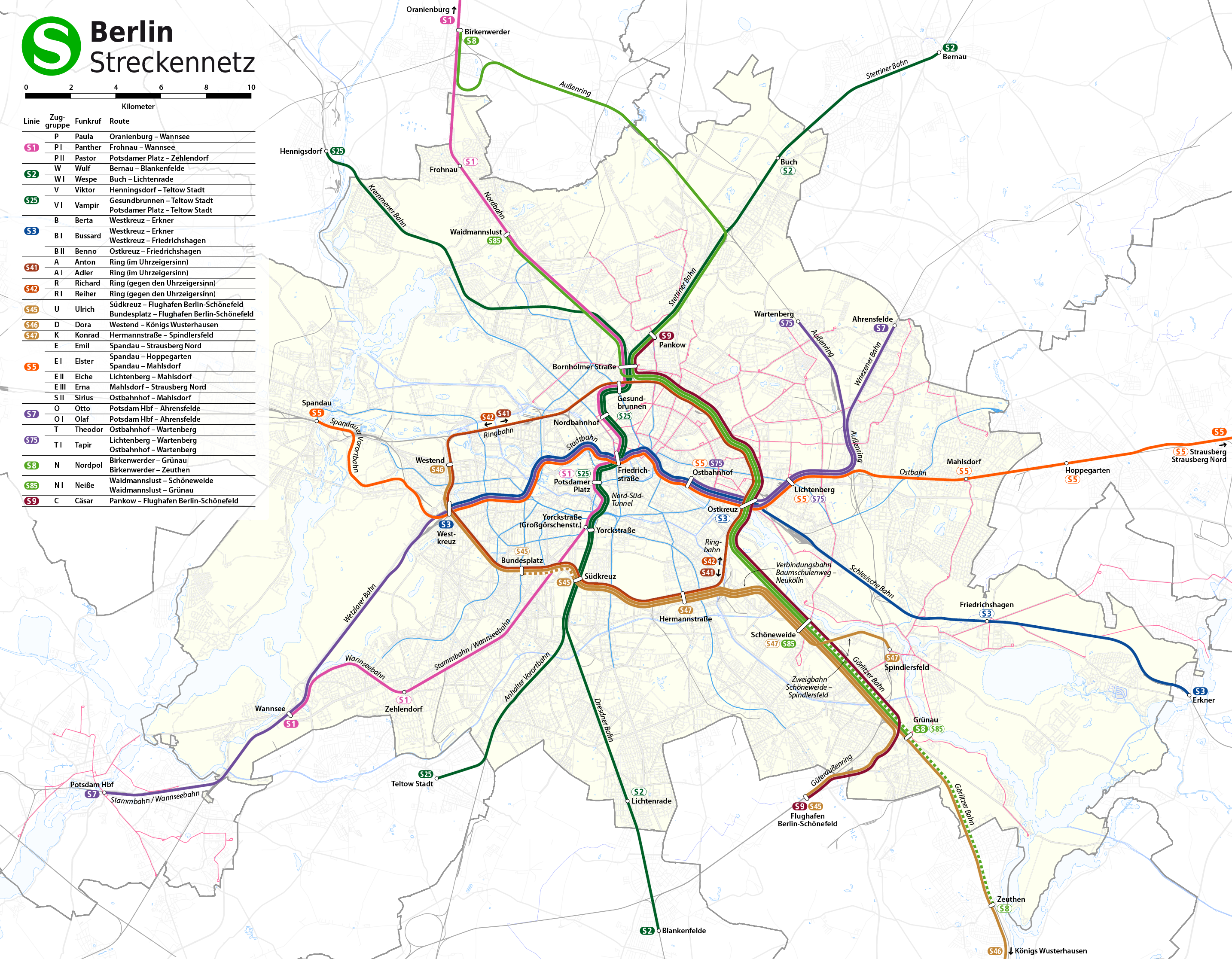
The Berlin S-Bahn network
The S-Bahn routes all feed into one of three core lines: a central, elevated east-west line (the Stadtbahn), a central, mostly underground north-south line (the Nord-Süd-Tunnel), and a circular, elevated line (the Ringbahn). Geographically, the Ringbahn takes the form of a dog's head and is colloquially known to Berliners by that name (Hundekopf). Outside the Ringbahn, suburban routes radiate out in all directions.
Generally speaking, the first digit of a route number designates the main route or a group of routes. Thus, S25 is a bifurcation of S2, while S41, S42, S45, S46, and S47 are all Ringbahn routes that share some of the same route.
| Line | Terminus | Route | Terminus |
|---|---|---|---|
| Wannsee | Nord-Süd-Tunnel | Oranienburg | |
| Blankenfelde | Nord-Süd-Tunnel | Bernau | |
| Teltow Stadt | Nord-Süd-Tunnel | Hennigsdorf | |
| Erkner | Stadtbahn | Spandau | |
| Südkreuz | Ringbahn | Südkreuz (clockwise) | |
| Südkreuz | Ringbahn | Südkreuz (counter-clockwise) | |
| ✈ Berlin-Schönefeld | Ringbahn | Südkreuz (↔ Bundesplatz) | |
| Königs Wusterhausen | Ringbahn | Westend | |
| Spindlersfeld | Ringbahn | Hermannstraße (↔ Südkreuz) | |
| Strausberg Nord | Stadtbahn | Westkreuz | |
| Ahrensfelde | Stadtbahn | Potsdam Hauptbahnhof | |
| Wartenberg | Stadtbahn | Spandau | |
| (Zeuthen ↔) Grünau | Ringbahn | Hohen Neuendorf | |
| (Grünau ↔) Schöneweide | Ringbahn | Waidmannslust | |
| ✈ Berlin-Schönefeld | Ringbahn | Blankenburg |
Stations in brackets are serviced at certain times only (Monday-Friday during offpeak in the case of S47 and during peak in the case of S8 and S85). S45 and S85 only run Mon-Fri.
Also, not every train reaches the nominal terminus of a line. For example, every other train on S1 runs only to Frohnau, five stops before Oranienburg, and the last stop on S3 towards Erkner which is reached by every train is Friedrichshagen. Similarly, some of the S2 trains terminate northwards only at Gesundbrunnen, and most of S5 trains run only to Strausberg or even Mahlsdorf, rendering Strausberg Nord the least frequented stop on the whole network.
On 31 August 2009 a few permanent changes to the line routes were applied. Due to renovation of the Ostkreuz station, which includes dismantling tracks connecting the Stadtbahn and the Ringbahn, S9 (formerly ✈ Berlin-Schönefeld ↔ Spandau) cannot turn west at this station any more. The line thus follows the Ringbahn and then branches northwards past Schönhauser Allee, like S2 and S8, and terminates at Blankenburg. To compensate for the diminished throughput on the Stadtbahn, the S3 (formerly Erkner ↔ Ostbahnhof) is extended westwards to Spandau. Minor alterations have been applied to the routes of S45 and S47, and S85 has been suspended on weekends.
Service hours[]
The normal daytime service runs fundamentally between 04:00 and 01:00 Monday-Friday, between 05:00 and 01:00 on Saturdays and between 06:30 and 01:00 on Sundays. However, there is a comprehensive nighttime service on most lines between 01:00 and 05:00 on Saturdays and 01:00 and 06:30 on Sundays, which means that most stations enjoy a continuous service between Friday morning and Sunday evening. One exception to this is the section of the S8 between Template:SBB stationsand Template:SBB stationswhich has no service during these times. Many other lines are totally unchanged in their operation, but some are curtailed or extended during nighttime service. Particularly, the S1, S2, S25, S41, S42, S75 are unchanged, and the S45, S85 have no nighttime service. The only line that is extended rather than curtailed is S5, which then runs westward as far as Template:SBB stationsto compensate for S7 servicing only the Template:SBB stations↔ Template:SBB stationssection. Remaining lines S3, S46, S47 and S9 terminate westwards at stations Ostkreuz, Südkreuz, Schöneweide and Treptower Park (northwards), respectively.
History[]
Inception[]
With individual sections dating from the 1870s, the S-Bahn came into existence in 1924. It was formed as the network of suburban commuter railways running into Berlin was converted from steam operation to a third-rail electric railway. The resulting network was primarily above-ground but with some subsurface tunnels.
Services on the Berlin S-Bahn were at first provided by the German national railway, the Deutsche Reichsbahn. Electrification of the existing suburban lines was completed around 1929, and thoughts turned to a new project: a tunnel that would join two spur lines that protruded into the city centre from the north and south. This tunnel, to be known as the Nord Süd Bahn, was a prestige project for the Nazis, and was opened in two sections. The first, from the north to Unter den Linden, opened in time for the 1936 Berlin Olympics; the final section, via Potsdamer Platz, opened the month after the Second World War began, in October 1939.
During and after World War II[]


Some Type 477 trains, built before World War II, remained in service until the early 21st century
Many sections of the S-Bahn were closed during the war due to enemy action. The Nord Süd Bahn tunnel was flooded on 2 May 1945 by retreating SS troops during the final Battle of BerlinTemplate:Citation needed. The exact number of casualties is not known, but up to 200 persons are presumed to have perished, since the tunnel was used as a public shelter and also served to house military wounded in trains in underground sidings. Service through the tunnel commenced again in 1947.
After hostilities ceased in 1945, Berlin was given special status as a "Four Sector City," surrounded by the Soviet Occupation Zone, which later became the German Democratic Republic (GDR). The Allies had decided that S-Bahn service in the western sectors of Berlin should continue to be provided by the Reichsbahn (DR), which was by now the provider of railway services in East Germany. (Rail services in West Germany proper were provided by the new Deutsche Bundesbahn.)
During the war, Berlin S-Bahn cars were overhauled at Luben to the east of Berlin. As that town, now known as Lubin, was ceded to Poland under the terms of the Potsdam Conference in 1945, 84 cars currently in the works were lost to Berlin. Further cars were sent east as war reparations, and eventually at least 287 cars were sent to Russia where they were converted for use in Moscow, Kiev and Tallinn. Additionally at least 80 two-car sets were retained in Poland, where they were used on suburban services in the Gdańsk-Gdynia region until 1976. Some of the latter cars were then converted for use in overhead line maintenance trains, and some still exist in that role. One set is preserved in its Gdańsk-Gdynia condition at a museum at Koscierzyna near Gdynia.[1]
Cold War[]
As relations between East and West began to sour with the coming of the Cold War, the Berlin S-Bahn soon became a victim of the hostilities. Although services continued operating through all occupation sectors, checkpoints were constructed on the borders to East Berlin and on-board "customs checks" were carried out on trains. From 1958 onwards, some S-Bahn trains ran non-stop through the western sectors from stations in East Berlin to stations on outlying sections in East Germany, so as to avoid the need for such controls. From this point onwards,Template:When all East German government employees were forbidden to use the S-Bahn as it travelled through West Berlin.
Alexanderplatz is an important transport hub in eastern Berlin
The western sectors of the city were physically cut off from East Germany on 13 August 1961 by what was later called the Berlin Wall, in a well-prepared plan to separate the two halves of the city – and at the same time, to divide the Berlin public transit network into two separate systems. Stadtbahn services were curtailed from both directions at the Friedrichstraße station. This station was divided into two physically separated areas, one for eastern passengers and one for westerners. Although the station lay within East Berlin, western passengers could transfer between S-Bahn lines or to the U-Bahn without passing through border checks, much like passengers changing planes at an international airport. The GDR also operated an Intershop in the portion of the station with services to and from West Berlin , where persons arriving from West Berlin (again without passing through border controls) could buy luxury goods such as tobacco and alcoholic beverages at discounted prices (compared to prices in West Berlin), provided they paid in hard currency, owing in part to the fact that Intershop customers did not pay West German taxes on their purchases. The West Berlin authorities were aware of this situation but did not impose stringent customs controls on such purchases out of political considerations. The Friedrichstraße station also become the main entry point for train and subway riders from West Berlin into East Berlin. Service on the Nord Süd Bahn was operated for western passengers only. It passed through a relatively short stretch under East Berlin territory in the city centre, and trains did not stop at the underground East Berlin S-Bahn stations, which were called ghost stations. Similarly, the Ringbahn services in the north of the city were curtailed at Gesundbrunnen from the west and Schönhauser Allee from the east, and in the south-east of the city at Sonnenallee and Köllnische Heide from the west and Treptower Park and Baumschulenweg from the East.
Because the S-Bahn was operated by the DR, West Berliners vented their frustration at the building of the wall by boycotting it since its fares were seen as subsidising the communist regime in the East. "Keinen Pfennig mehr für Ulbricht," or "not a penny more for Ulbricht," became the S-Bahn opponents' chant. Within days of the Berlin Wall being built, the BVG, with assistance from other transit companies in West Germany, began providing "solidarity with Berlin buses" – new bus services which paralleled the S-Bahn lines and therefore provided an alternative. After many years of declining passenger usage and difficult industrial relations between the West Berlin workforce and their East Berlin employers, most of the western portion of the S-Bahn was closed down in September 1980 following a strike. A 20-minute service was still provided on the Stadtbahn from Westkreuz to Friedrichstraße as well as services on the Nord-Süd Bahn between Frohnau, Friedrichstraße, Lichtenrade or Wannsee.
By contrast, during the same period, services on the S-Bahn in East Berlin were increased and new lines built as housing projects expanded eastward from the city centre. With most of the U-Bahn located in West Berlin, the S-Bahn became the backbone of the East Berlin transit network.


The track system is a fully separated and independent rapid transport system within the city.
The 1980 incidents turned media and political attention towards what was left of West Berlin's S-Bahn network. The city government decided to enter negotiations with East Germany which were finally successful. On 9 January 1984, the BVG took over the responsibility for operation of S-Bahn services in West Berlin. After further closedowns that same day, a limited service was restored, initially comprising only two short sections without direct interchange between them. In the years between 1984 and 1989, several sections were gradually reopened, resulting in a network of 71 km and three lines - with one line running on the Stadtbahn and two on the Nord Süd Bahn - comprising about 50% of West Berlin's original network. This development brought West Berlin's S-Bahn back into public awareness and restored its popularity.
Until 1984, all Berlin S-Bahn routes were allocated letters as a means of identifying the route of the train. These letters were occasionally followed by Roman numerals to indicate a shortworking or bifurcation in the service (e.g., A, BI, BII, C,) and are still used internally by the Berlin S-Bahn GmbH for timetabling and in conjunction with radio call-signs to each train unit. When the BVG took over the responsibility for operation of S-Bahn services in West Berlin in 1984, it introduced a new unified numbering scheme for both the S-Bahn and the U-Bahn, which it also operated. Existing U-Bahn route numbers were prefixed with the letter U, while the new S-Bahn route numbers were prefixed with the letter S. This system of numbering routes was used in all other West German cities, and was extended to the S-Bahn service for the whole city after reunification.
Reunification[]

A modern S-Bahn train at Griebnitzsee
After the Berlin Wall came down in November 1989, the first broken links were re-established, with Friedrichstraße on July 1, 1990 as the first. The BVG and DR jointly marketed the services soon after die Wende. Administratively, the divided S-Bahn networks remained separate in this time of momentous changes, encompassing German reunification and reunification of Berlin into a single city, although the dividing line was no longer the former Berlin Wall. DR and BVG (of the whole of reunified Berlin from January 1, 1992 after absorbing BVB of East Berlin) operated individual lines end to end, both into the other party's territories. For example, S2 was all-BVG even after it was extended northward and southward into Brandenburg/former GDR territory. The main east-west route (Stadtbahn) was a joint operation. Individual trains were operated by either BVG or DR end-to-end on the same tracks. This arrangement ended on January 1, 1994 with the creation of Deutsche Bahn due to the merger between DR and the former West Germany's Deutsche Bundesbahn. All S-Bahn operations in Berlin were transferred to the newly formed S-Bahn Berlin GmbH as a subidiary of Deutsche Bahn and the BVG withdrew from running S-Bahn services.
Technically, a number of projects followed in the steps of re-establishing broken links in order to restore the former S-Bahn network to its 1961 status after 1990, especially the Ringbahn. In December 1997 the connection between Neukölln and Treptower Park via Sonnenallee was reopened, enabling S4 trains to run 75% of the whole ring between Schönhauser Allee and Jungfernheide. On 16 June 2002, the section Gesundbrunnen - Westhafen also reopened, re-establishing the Ringbahn operations.
2009 service reductions[]
On 20 July 2009, known locally as "Black Monday," S-Bahn service was significantly reduced due to safety checks on the trains ordered by the German Federal Railway Authority. Having so many trains taken out of service for inspection left less than 30 percent of the system's rolling stock available for revenue service. Eight routes, including most through services on the Stadtbahn, were closed and on other lines headways were reduced to 20 minutes and trains shortened.
Some minor restorations in service were made on 3 August 2009; however, the full timetable will not be available before December 2010 and full regular service not before 2011.
Due to new inspection troubles the S-Bahn network was again reduced dramatically on 8 September 2009. As of that date, three quarters of the trains were withdrawn from the network due to inspection and faulty brake cylinders. There were again no trains on the Stadtbahn between Westkreuz and Alexanderplatz, and no S-Bahn trains to Spandau. Trains on the circle lines, S41 and S42, are running at 10-minute intervals. Other routes are running with extended intervals and reduced distances.
As of April 2010, all lines, apart from the S45 and S85, are running again. Trains run to all destinations although some routes don't run the complete distance or the lines are not operated in their normal frequency.
Infrastructure work[]
Starting in 2010, DB Netz is replacing mechanical train stops on the S-Bahn network with electronic balises.[2]
Expansion[]
Redevelopment projects[]
- Ostkreuz
Demolition of the southern access 2008
Already in 1988, the German State Railways had plans for the transformation of the Ostkreuz presented [3] In 2007 began the long postponed renovation of the station. In addition to the complete redesign of the track field, in addition, two new regional platforms. The station is designed to be barrier-free with the installation of elevators and escalators. The operation on the east-west routes of the S-Bahn will be conducted in future in the direction of operation, the platform will take the D train to the city and on the platform of the E trains to the east. At the same time the route is adjacent to the station Warsaw Street and this renovated train station [4] The cost of rehabilitation are currently listed with 411 million euros [5]
The station is Ostkreuz with nine lines (four on the light rail and five on the Circle Line) one of the busiest stations in the network. Since the reorganization takes place during full operation, not a mandatory completion date is known. German Rail expects to complete in 2016 [6]
With the progress of construction work on 31 August 2009, the South Stand and the platform of the Ostkreuz A decommissioned. This line had to change the result. The construction plans shall provide that connection by 2014 [6] restore, so that after the completion of re-direct traffic from the southern Circle Line on the Light Rail is possible. A platform will not receive the Südringkurve but again. The North curve of the station Ostkreuz (Warsaw street - Frankfurter Allee) was closed in 2006 and dismantled in the coming years. Its restoration is planned.
In October 2009, the new regional station of the Circle Line was far completed that the S-Bahn trains on the Circle Line to use these now and could begin the demolition of the old ring-S-Bahn platform.
- Goerlitz Railway (Baumschulenweg - Grünauer Cross)
Renewal of the Görlitz rail bridges over the Teltowkanal November 2009
The rehabilitation work on the Goerlitz Railway was on 12 July 2006 started [7] The stations Baumschulenweg and Adlershof were built [8] {{[9] {{[10] The platform was in Adlershof in transforming a new location on the Rudower Chaussee. The construction cost for this station were reported at 33 million euros. The latest plans by Deutsche Bahn to see a new building of the station Schöneweide before, after the realization of the Tram to drive through a tunnel to Sterndamm [11] The project also includes upgrading the track Grünauer Cross - Berlin-Schoenefeld airport, and railway stations Wildau. A total of 335 million euros for the construction work had been used. These costs include the station Schöneweide not. The completion of the construction work is scheduled for 2010.
- Station Oranienburgerstrasse
On 19 | At the station Oranienburgerstrasse# Oranienburgerstrasse Public Transport January 2010, the construction of a second output started. He is the last underground station on the North-South route, which has only one output. The construction costs are indicated with 1.3 million €. After the fire in the station pickup station on 10 August 2004 stipulates that all underground stations are retrofitted to a second output [12]
New lines[]
Access Airport Berlin Brandenburg
- Extension airport Berlin-Schönefeld - Flughafen Berlin Brandenburg
For the future Airport Berlin Brandenburg in Schönefeld in the south of Berlin S-Bahn line from the current end point Airport Berlin-Schoenefeld is extended over a wide berth to the new terminal. Directly below the terminal under construction, Berlin Brandenburg, a station will be built with six tracks. Four tracks are for the long distance railway as provided through station. With the approach from the west two tracks for the train are provided. In early July 2008, the first 185 meters long section of the station in the shell as far as completed, the fact that the terminal building to be erected. On 24 July 2009, the airport company the shell of the airport railway station and the first part of the tunnel at the SQL {{pass Cite error: Closing </ref> missing for <ref> tag {{[13] [14] The construction costs indicated at 636 million euros. This includes also the cost of which contain both long-distance rail link to be created. [14]
Planned route of the S21 as a second north-south S-Bahn
| planning | |
|---|---|
| Template:BS2Template:BS2Template:BS2Template:BS2Template:BS2Template:BS2Template:BS2Template:BS2 |
- Planning line S21 (Second North-South Railway - first construction phase)
The second North-South Rail will link the northern ring road to the main train station, train station Potsdamer Platz and the Wannsee train to the southern ring road. Already taken place in the 1907-1910 competition,Greater Berlinby Albert Sprickerhof one-way by today's plans almost identical to the proposed course. [15] Since then, there were a number of planning options to such a route, a similar line in the planning for the "world capital Germania" in the 1930s was provided [16]
The line will be built in sections. In 2005, the zoning approval for the northern part of the route of the Circle Line to Central Station adopted. [17] In October 2009 a loan agreement between the Senate and the German track for the first Section closed. Costs shall be in it with € 226.5 million [18] On 27 November 2009, started the preparatory work for this phase of construction at the main station. . For the underground excavation in Invalidenstrasse diaphragm walls incorporated into the soil and covered with a reinforced concrete lid [19] {{[20] {{[21]
This stage involves the construction of a curve to the West train station West Harbour, and an East Stand to the S-Bahnhof Wedding in front on the northern ring. The Ausfädelung of these lines has already been prepared for the construction of the North-South mainline and 2006, structurally. From there, the existing line in a southerly direction (in the tunnel layer) to the Central Station east of the north-south mainline run. The realization of an intermediate station by the working namePerleberger Bridge(as the Tower Station in V-shape) is provided as an option. Until 2016, this 1,600-meter-long section to be built [22]
plans for the expansion of the S-Bahn[]
Expansion decision[]
- Planning line S21 (Second North-South Railway - second stage)
The construction of the second section of the S21 is to begin no earlier than 2018 and be completed until 2023. The new suburban rail line will result in tunnel position from the railway station past the Reichstag Potsdamer Platz. It is equal to the Brandenburg Gate in the existing tunnel of the North-south S-Bahn and open out to him Potsdamer Platz to use. The first north-south S-Bahn in 1939 was designed with a view to a second four-track route. The cost of the S-Bahn rail line (phases 1 and 2) are to present information (2009) amount to 317 million euros. [19] The benefits of an additional budget to the east of Reichstag building s is still under investigation. Through him, the cost would increase to about 330 million euros.
For the other phases of construction to the southern ring road are currently no dates. They have so far only in the Berlin land use plan defines [23]
Considerations for further extensions[]
Since reunification there were considerations that are no longer used since 1961 or 1980 lines [24] rebuild and add to the network through some new lines. Many of these plans have changed several times since then, or were abandoned.
Following a decision of the Berlin House of Representatives, the goal, the S-Bahn network is essentially the extent of 1961 to restore. This was stated in an agreement between the web, the Federal Ministry of Transport and the Senate on 4 November 1993 [25] [24] The net should be restored until 2002. On this basis, the plans were included in the land use plan of 1995. In a study of the transport development of the then Department for Transport and businesses in 1995, the plan was published for one destination network. Only the connections Jungfernheide - Stresow, Spandau - Staaken and Zehlendorf - chaff which existed until 1980 incorporated in these plans not occur. Political will is now meant only symbolic, since beyond already several projects on the former purpose or value. The tense budget situation, changing traffic flows and the alternative development through regional trains leads to complete cancellation or postponement of already planned projects.
Below is described on the basis of how these plans have changed over time and how the possibilities of realization represented today. For many routes now only one route control systems is planned.
The basis used here the following documents:
- 'FNP (yes = in the FNP (Berlin) mentioned, no = not in the FNP (Berlin) mentioned, tr = route control systems in the country's transport plan Brandenburg)
"Land Use Plan the city of Berlin" - Stand Cite error: Invalid <ref> tag; invalid names, e.g. too many
"Land Transport Map Brandenburg 2008-2012" [26]
- 'Target network (VB = urgent requirement, WB = further need, TR = line control systems, - = not included)
". Transport planning for Berlin - Materials for Urban Development Plan for Transport (Department for Transport and farms Berlin 1995) "Berlin in travel" (Senate Department for Construction, Housing and Transportation Berlin 1997)
- DB
"Hub Berlin - Building for the S-Bahn (S-Bahn Berlin GmbH & DB project Verkehrsbau GmbH Berlin 2001) [27] Update these documents through current news reports, press releases of the Senate and the surrounding communities and cities, as well as the work of various citizens groups.
| FNP | Destination network | DB | Route |
|---|---|---|---|
| during World War II shut down routes | |||
| ' Cheruskerkurve ( Planning line S21 ): Julius-Leber-Brücke ↔ Südkreuz (about 0.8 km)[28] {{cite [29] | |||
| yes | TR | no | The so-called "Cheruskerkurve" was until 3 July 1944 part of the South-ring hairpin. In 2000, the FNP has been added to this direct connection of the Wannsee train with the ring rail as the 4th phase of the "S21". Exact dates are not yet established. [16] |
| routes to 13 August 1961 passed (close down because of construction of the Wall) | |||
| Blankenfelde ↔ ↔ Dahlewitz Rangsdorf (about 4.8 km)[28] | |||
| tr | TR | yes | In the S-Bahn Berlin in 2001 booklet "hub Berlin - Building for the S-Bahn" was recorded this track yet [27] It has become a quiet recovery. The municipality of Rangsdorf is ready for a reconnection of the S-Bahn. The mayor of the municipality has advocated, as a citizens' initiative has made Internet [30] In the country's transport plan Brandenburg from 2008 to 2012 this route is advocated [26] The federal government would in the detection of requirements of this section will provide funding. [31] The state of Brandenburg has been carried out, no plan approval process. |
| Spandau ↔ Nauener road ↔ Hackbusch road ↔ Albrechtshof ↔ Seegefelder ↔ Falkirk (↔ Falkirk Park City ↔ Finkenkrug) (about 7.8 km / 10.7 km)[28] | |||
| yes tr |
VB | yes | The benefits of extending the S-Bahn from Spandau for Falkirk or Finkenkrug was in an economic study of the Federal Government justified and the states of Berlin and Brandenburg. In March 2008 the project was a cost-benefit ratio of 1: 1.31 certified [32] [33] would in building this section of the populous western part of Spandau be connected to the rail network. The design is controversial. The Berlin Senate (the SPD and Left Party) is for the construction, the Greens and the CDU of the Havelland have objected. The town of Falkirk and the communities behind Finkenkrug fear a dilution of the RE and RB connection. If the fiscal position improved the city of Berlin, this route, at least in Berlin territory, [34] seen as most likely to be realized . The federal government would provide for an extension to Falkirk has no funds, but an extension on the Berlin area, up Hackbusch street or Albrechtshof eligible for financing. [31] A new study has shown that the way to Hackbusch street benefit cost ratio is 2.64. The construction costs were calculated with 37 million €. The Senate Department for Urban Development is expecting a possible construction start in 2012 [35] |
| graveyard orbit: Wannsee ↔ ↔ Dreilinden Stahnsdorf (about 4.2 km)< ref name = "SHUT DOWN" /> | |||
| yes tr |
TR | no | The rebuilding of the track is by the highway laying ( A 115) today rather complicated. The route of the railway is kept to a cemetery in Berlin and Brandenburg area yet. For the reconstruction, is a citizens initiative (see reflections on new lines - ring closure) [36] In particular, the Catholic Church has an interest in the reopening of this route. It relies on old contracts with the car and tried to build sue [37] |
| routes to 17 September 1980 passed (shut down after strike, 1980) | |||
| Siemens train: Jungfernheide ↔ Wernerwerk ↔ Siemensstadt ↔ garden field (↔ Haselhorst ↔ Daum road ↔ Hakenfelde) (about 4.0 km / 8,0 km)[28] | |||
| yes | TR | yes | Reactivation of the Siemens train, but only with a very structurally complex extension of the Havel forwaterSpandau (possibly to hook field) would be useful to operate is very unlikely. An investigation to continue to hook the field, under theplanningline S21 showed excessive construction costs [38] The development of the Siemens town even as early as 1980 by covered subway line U7. While in 2001 had reported the German railway route to the garden or field as planning, [27] she has applied this route in 2007, the brance Federal Railway [39] The Senate holds the land use plan to determine time until at the junction box garden. |
| trunk line: Zehlendorf - Zehlendorf Süd - chaff-Kleinmachnow (- Kleinmachnow Schleusenweg - Dreilinden Europarc) (about 2.2 km / 5,3 km)[28] | |||
| yes tr |
- | no | After the Second World War, after initial steam operation, prepared in 1948, the short section of Zehlendorf and chaff for the electric train and so used until 1980. A cost-benefit analysis for a regional rail operation of the continuous base rail route, from the year 2008, did not expect the traffic volume needed for reconstruction [40] [40] [40] [40] Since 2008, there are discussions between the trunk line and Zehlendorf Griebnitzsee as S-Bahn line to be restored. [41] On 10 June 2009, the district Steglitz-Zehlendorf, Kleinmachnow the community,the Europarc Dreilindenand theGerman Railways International GmbHa preliminary study for a possible train operation on the eastern part of the route between Zehlendorf and the Europarc Dreilinden the . [42] {{cite [43] where it is not yet an official planning. |
| routes to 20 September 1983 there were (isolated operation after construction of the Wall) | |||
| Hennigsdorf - Hennigsdorf Marwitz road - Hennigsdorf North - Hohenschöpping - Velten (about 5.9 km)[44] | |||
| tr | WB | yes | The city Velten is trying to turn around the connection to the S-Bahn network, and in 2008 a feasibility study commissioned [45] After the Wall went to 1983 a line island of Hennigsdorf according to Velten. A cost-use study has been approved by Deutsche Bahn. By 2001, this road was still planning official of the web. [27] |
| 'Reflections on new lines | |||
| S21 line planning Part 1: Potsdamer Platz - Gleisdreieck - Yorckstraße (about 2.1 km) and Part 2: Gleisdreieck - Yorckstraße (Großgörschenstraße) (approximately 0.9 km) | |||
| yes | WB | no | This new line represents the 3rd Planning stage of the "S21" You dar. south of the station Potsdamer Platz is unthread. Here there since the 1930s constructed provisions [46] then runs parallel to the railway tunnel, stopping at the underground station Track triangle and help with a Western road into the station "Yorckstraße (Großgörschenstraße)" and in the eastern railway station "Yorckstraße" open. Schedules are also available for this part of the "S21" is not yet known. [16] When Debis park, south of the Landwehr canal is to pursue theS21was taken upstairs. [47] |
| Berlin outer ring (local tangent ):< br /> Part 1: Karower Cross - Sell Home Bridge (approximately 1.0 km) and Part 2: Sell Home Bridge - Park City - Wartenberg (about 3.0 km)'[28] Part 3: Springpfuhl - Biesdorfer Cross - South Biesdorf - Biesenhorster - Wuhlheide - FEZ - Spindlersfeld - Glienicker Straße - Grünauer Cross (about 13.3 km) | |||
| yes | (1) WB (2) VB (3) TR |
(1) yes (2) yes |
is this is a plan that was developed in the early 1960s in the GDR. In the 1980s it was revived and expanded. Now in addition were related curves of the Berlin outer ring (BAR) to train Szczecin in the north (Karower cross) and Görlitz Railway in the south (Grünauer Kreuz) are provided. A connection to the Silesian railway station Wuhlheide [48] By the end of the GDR were the German railways have already provided some constructed provisions, such as . The preparation of the S-Bahn tracks between Adlershof and Köllnische suburb, a three-pronged S-Bahn line from Altglienicke to bridge abutment on the north side of the eagle frame and the line on the section Sellheim bridge to Wartenberg [49] {{cite [48] As part of this planning was also the construction of a depot provided Cite error: Invalid <ref> tag; invalid names, e.g. too many These plans were incorporated in the FNP, but a long time pursued any further. . In the web of the sectionWartenberg'↔ Sellheim bridgeuntil 2001 was still officially in the planning name="DREHSCHEIBE" /> In the spring of 2009 decided Cite error: Invalid <ref> tag; invalid names, e.g. too many that the planning is to prepare the transport tangent. But after a local train is provided on the outer ring. On "Karower Cross" is 2013, a new Tower Station for the regional railway and the S-Bahn (S2) formed [50]
|
| Ring Final: City of Teltow - Teltow Isarstraße - Stahnsdorf Lindenstraße - Stahnsdorf (6.5 km) | |||
| tr | - | no | . The first consideration for such a train connection were already employed in the late 1930s [51] [28] first earthworks were carried out in the Second World War. The route was kept open. . In 1991 this route official Senate Planning [52] The considerations were of distances from a citizens' initiative [36] up again. It is the graveyard orbit (see above) are involved in this route and with a direct connection to the city of Teltow Wannsee arise. |
| Abandoned plans (plans that existed only after 1945) | |||
| east-west S-Bahn Anhalt Station ↔ Kochstraße ↔ Moritzplatz ↔ Görlitz Station ↔ Lohmühlenstraße ↔ Kiefholzstraße ↔ Plänterwald (about 6.1 km)[53] | |||
| no | no | no | View products this route is a planning, in the 1930s in connection with the was World Capital Germania Germania-planning began and was first in the revised land use plan of the Senate in 1985 finalized on ice. During the construction of the underground station "Anhalt station" already created structures with transfer. Moritzplatz is located under the subway station, a transfer station in shell production, which was created in the 1920s for a subway line. As part of this planning should be used for the S-Bahn. More constructed provisions do not exist. At times, was in addition a direct connection between the cook road planned to Potsdamer Platz. |
| Heidekrautbahn: Karow - Schönerlinde - Schönwalde - Basdorf - Wandlitz - Wandlitzsee (approximately 18.1 km) ' '{{[54] | |||
| no | no | no | In 1976, came in what was then East Germany on a timetable of these S-Bahn route. This plan was agreed by the Berlin City Council with no parent body. However, it was taken up and pursued until 1980. The tram would have replaced an existing suburb name. The only building project was implemented to connect the so-called "heather train" to the S-Bahnhof Karow. Officially, the plan was not abandoned until the end of the GDR, after the reunification of the plans were rejected. |
Further plans[]
In addition to the consideration of route extensions are developing programs for lines and stations. In future, the single-track routes to Hennigsdorf, Teltow City, Strausberg Nord be double track sections. The Dresden path on which owns the train tracks will not have their own part, as a feeder for the new airport Berlin-Brandenburg will be removed and the S-Bahn own tracks. [55] In addition, each year several stations with elevators and ramps designed accessible. The construction of additional access is provided at some stations in the existing network. In addition to other stations occur in the existing network. The station Köpenick to 2011/12 for the regional train station built and for the regional train station Karlshorst be abandoned [56]
The basis used here the following documents:
- FNP (Yes = included in FNP, no = not included in FNP, empty = station in Brandenburg)
"Land Use Plan the city of Berlin" - Stand Cite error: Invalid <ref> tag; invalid names, e.g. too many
- Target network (VB = urgent requirement, WB = further need, LB = long-term needs). Transport planning for Berlin - Materials for Urban Development Plan for Transport (Department for Transport and farms Berlin 1995)
"Berlin in travel" (Senate Department for Construction, Housing and Transportation Berlin 1997)
| FNP | Destination network | Station | Route | Location (adjacent existing railway stations) | Note |
|---|---|---|---|---|---|
| LB | Arkenberg | Berlin outer ring | Blankenburg and Mill Beck Mill Monk | Constructed provisions available - plan was abandoned | |
| yes | LB | Biesdorfer Cross | Ostbahn | Friedrichsfelde East and Biesdorf | Transition to transport tangent |
| yes | LB | Blockdammweg | Silesian railway | Depot Rummelsburg and Karl Horst | |
| yes | LB | Bohnsdorf Road | Freight outer ring | Green Mountain Avenue and the airport Berlin-Schoenefeld | |
| yes | VB | Borsigwalde [57] | Kremmener train | Eichborndamm and Tegel | |
| yes | VB | Book South | Szczecin railway | Karow and Book | |
| yes | LB | Bird Street [58] | Berlin outer ring | Blankenburg and Mill Beck Mill Monk | Constructed provisions exist [59] |
| yes | WB | Bürknersfelder | Berlin outer ring | Miter Seestraße and Springpfuhl | |
| yes | LB | Charlottenburg Chaussee | Spandau suburb train | Pichelsberg and Stresow | |
| yes | LB | Dudenstraße | Dresden Railway | Yorckstraße and Südkreuz | |
| LB | Glasower dam | Dresden Railway | Mahlow and bright field (Kr Teltow-Fläming) | ||
| yes | LB | Grünauer Cross | Goerlitz Railway | Adlershof Grünau | Transition to transport tangent |
| yes | WB | Kamenzer dam | Dresden Railway | Attila street and Marie Felde | |
| yes | WB | Karower Cross [50] | Szczecin railway | Blankenburg and Karow | Additional regional station and a transition to transport tangent |
| yes | LB | Kiefholzstraße | Circle Line | Treptow Park and Sun Alley | |
| yes | LB | Komturstraße | Circle Line | Hermann Street and Tempelhof | |
| LB | North Mahlow | Dresden Railway | Lichtenrade and Mahlow | ||
| no | LB | New bank | Circle Line | Beusselstraße and Jungfernheide | The plan was abandoned |
| yes | LB | Or street | Circle Line | Hermann Street and Tempelhof | |
| yes | VB | Schoenerlinder road [58] | Berlin outer ring | Blankenburg and Mill Beck Mill Monk | |
| yes | LB | Schorfheide Street | Northern Railway | Wilhelmsruh and Wittering | |
| yes | WB | Wuhletalstraße | Wriezener train | Mehrower Avenue and Ahrensfelde |
See also[]
- List of Berlin S-Bahn stations
- List of metro systems
References[]
- ↑ Template:Cite news
- ↑ Script error: No such module "citation/CS1".
- ↑ [citation needed]
- ↑ [citation needed]
- ↑ Template:Web
- ↑ 6.0 6.1 Template:Web
- ↑ [citation needed]
- ↑ {. {source web | title = Walk In July, the new S-train platforms to the grid: What to do then still | url = http://www.s-bahn-berlin.de/aktuell/2009/116_neubau_bhf_adl_bsw.htm%7Czugriff = 2009-12-15 | daturm = 2009-04-30 | work = www.s-bahn-berlin.de|autor=S-Bahn Berlin GmbH}}
- ↑ Internet source | title = Start of construction fundamental restructuring of the S-Bahn line between Baumschulenweg and the Green Cross Auer | url = http://www.s-bahn-berlin.de/presse/presse_anzeige.php?ID=336%7Czugriff=2009-12-15%7Cdatum=2006- 07-12 | www.s-bahn-berlin.de|autor=S-Bahn factory = Berlin GmbH}}
- ↑ Internet source | title = Basic Renewal 2006/09 | factory = Berlin-Görlitz Railway | url = http://www.goerlitzer-bahn.de/modules.php?op=modload&name=Sections3&file=index%7Czugriff=2009-12-19}}
- ↑ Template:Internet resource.
- ↑ Template:Internet Resources
- ↑ Internet source | url = http://www.bsisb.de/default_f.htm?/bbi_anb/bbi_anb00b.htm%7Ctitel=Bahnanbindung of Airport BBI | access = 2009-10-30 | author = Detlef Hoge | www.bsisb.de are factory =}}
- ↑ 14.0 14.1 Cite error: Invalid
<ref>tag; no text was provided for refs namedBBI - ↑ Cite error: Invalid
<ref>tag; no text was provided for refs namedTUNNEL - ↑ 16.0 16.1 16.2 Template:Web
- ↑ Federal Railway Office, plan approval to the plan of the DB Netz AG for the construction project S21 - North Ring connection to Hauptbahnhof, Berlin-West Port - Berlin Hauptbahnhof - Berlin-Wedding, 12 February 2005.
- ↑ Template:Web
- ↑ 19.0 19.1 [citation needed]
- ↑ literature | anthology = Point 3 | Band = 22 / 2009 p. 4 | title = construction preparations for future S21}}
- ↑ literature | anthology = The Times | Band = 1 December 2009 | title = Tunnel work prior to the train station | online = 2.96391 million [http://www.tagesspiegel.de www.tagesspiegel.de ]}}
- ↑ Template:Internet source
- ↑ Template:Internet source
- ↑ 24.0 24.1 Cite error: Invalid
<ref>tag; no text was provided for refs namedGESAMTNETZ - ↑ [citation needed]
- ↑ 26.0 26.1 Cite error: Invalid
<ref>tag; no text was provided for refs namedBRANDENBURG - ↑ 27.0 27.1 27.2 27.3 [citation needed]
- ↑ 28.0 28.1 28.2 28.3 28.4 28.5 28.6 Template:Source web
- ↑ | title = Land Use Plan Cheruskerkurve Journal | Online = [http://www.stadtentwicklung.berlin.de www.stadtentwicklung.berlin.de] | publisher = Senate Department for Urban Development | Access = 2009-12-18 }}
- ↑ Template:Source
- ↑ 31.0 31.1 Cite error: Invalid
<ref>tag; no text was provided for refs namedBUNDESTAG - ↑ [citation needed]
- ↑ [citation needed]
- ↑ [citation needed]
- ↑ [citation needed]
- ↑ 36.0 36.1 Template:Source web
- ↑ [citation needed]
- ↑ [citation needed]
- ↑ Template:Web
- ↑ 40.0 40.1 40.2 40.3 [citation needed]
- ↑ [citation needed]
- ↑ public from Template:Source web
- ↑ | title = S-Bahn connection Zehlendorf-Kleinmachnow three-Linden - Preliminary study results | Online = [http://www.bik-kleinmachnow.de www.bik-kleinmachnow.de] | publisher = DB International GmbH | day = 9 | Month = June | year = 2009 | Access = 2009-12-18}}
- ↑ Cite error: Invalid
<ref>tag; no text was provided for refs namedSHUT DOWN - ↑ [citation needed]
- ↑ Template:Web to
- ↑ Template:Literature
- ↑ 48.0 48.1 | title = Kramers jump - By S train from Schönefeld Karower Cross |? compilation = traffic Historical sheets | Band = 3 / 2009 | pages = 62ff | publisher = traffic Historical leaves eV}}
- ↑ [citation needed]
- ↑ 50.0 50.1 [citation needed]</ Karower Cross
- ↑ Cite error: Invalid
<ref>tag; no text was provided for refs namedGROESSENWAHN - ↑ {was {cite | title = S-Bahn plans in the region Berlin | compilation = Berlin Transport sheets | Band = 8 / 1991 | pages = 174ff | Publisher = Arbeitskreis Berlin transport }}
- ↑ Template:Source web
- ↑ literature | anthology = Traffic History Sheets | Band = = 62ff 3/2001/Seiten | Publisher = traffic leaves Historical Association | title = Electric in the heather}}
- ↑ Cite error: Invalid
<ref>tag; no text was provided for refs namedHUB - ↑ [citation needed]
- ↑ [citation needed]
- ↑ 58.0 58.1 Template:Internet source
- ↑ Cite error: Invalid
<ref>tag; no text was provided for refs namedBW
External links[]
| Wikimedia Commons has media related to Berlin S-Bahn. |
- S-Bahn Berlin GmbH
- regular network (PDF)
- VSWB.de - Disused Rails and Lanes in Berlin
- Google Mashup with S-Bahn Map (beta)
- Flyer containing special map due to the cut traffic situation since July 20, 2009
| |||||||||||||||||||||

.jpg)
| ||||||||||||||||
Template:Link FA bn:বার্লিন এস-বান ca:S-Bahn de Berlín cs:S-Bahn v Berlíně da:Berlins S-Bahn de:S-Bahn Berlin es:S-Bahn de Berlín fr:S-Bahn de Berlin hr:S-Bahn Berlin it:S-Bahn di Berlino hu:S-Bahn Berlin nl:S-Bahn van Berlijn ja:ベルリンSバーン no:Berlins forstadsbaner pl:S-Bahn w Berlinie pt:S-Bahn-Berlin ru:Берлинская городская электричка sk:Berlínska rýchlodráha sr:Берлинска приградска железница fi:Berliinin S-Bahn sv:Berlins pendeltåg tr:Berlin S-Bahn uk:Берлінська міська електричка zh:柏林城铁